
Aspen Acres Fire over 100,000 acres, over 60% contained

Updated
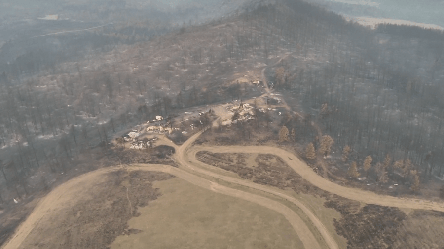
(SOUTHERN COLORADO) — The Aspen Acres Fire in Southern Colorado has burned 100,224 acres and, as of Saturday, July 18, is at 61% containment, according to the Northern Rockies Complex Incident Management Team 6 (CIMT6) Incident Commander, Rich Cowger. 1,611 personnel are battling the fire.
Fire operations update
Incident Commander Cowger provided the following details on firefighting operations from Friday night, July 17, into Saturday morning:
-
On Friday, an unauthorized drone entered the fire airspace, forcing aircraft to stand down temporarily. Any unknown aircraft within the restricted airspace halts aerial operations and puts firefighters at risk. It’s important for the public to understand that flying a drone near a wildfire is not only dangerous, but it is a federal offense. If you fly, we can’t.
-
For reports from the public regarding unauthorized drones, please contact the Pueblo County Non-Emergency Line at 719-583-6250.
-
-
Firefighters made solid progress yesterday across multiple parts of the incident. Overnight, fire activity stayed relatively quiet, allowing firefighters to strengthen previous gains. On the east edge, good progress has been made in moving portions of the line into patrol, mop‑up, and initial repair work.
-
In the area referred to as the “chicken foot” on the southwest side of the fire, some short‑range spotting occurred near Rye yesterday but was quickly caught by firefighters.
-
Crews were also able to secure spotting north of the Greenhorn Mountain using both ground resources and aircraft. Firefighters worked through the night to reinforce those improvements, setting a solid foundation for Saturday’s operations.
-
To build on overnight progress, on Saturday, newly arrived hotshot crews will deploy to this area with support from aircraft to tighten lines and reduce the chance of fire spread.
-
These highly trained teams specialize in working in the steepest, most difficult terrain and will focus their attention on the active fire front northwest of Rye.
-
Strengthening containment here is critical due to the challenging landscape and proximity to nearby communities.
-
-
On the western side near Saint Charles Peak, San Isabel Lake, and northwest of Rye, crews continued improving primary and secondary defensive lines.
-
Fire behavior in this area was less active than earlier in the week, giving firefighters a chance to strengthen the line and prepare for potential firing operations if conditions allow.
-
Heavy machinery is working north of Round Top Mountain and the Mingus Ranch area to reduce future erosion concerns.
-
-
Burned Area Emergency Response teams are also assessing the burn scar to understand impacts to property, infrastructure, and watersheds. Their evaluations help determine where treatments are needed to reduce risks of flooding, mudslides, and erosion.
-
Suppression repair continues in areas with established containment to protect nearby communities and natural resources.
-
A growing number of people have been entering the fire area. For everyone’s safety, the public is asked to stay out of active fire zones so firefighters can work without interruption or added risk.
-
Saturday is forecast to bring a warmer and drier pattern across the fire area, with mostly sunny skies and a low chance of rain. Easterly winds are expected to increase in the early afternoon, producing gusts around 20–25 mph. Most thunderstorms are expected to remain west and southwest of the fire, leaving only a minimal chance of lightning.
-
Weather conditions are expected to support more active fire behavior today, especially in areas with very dry fuels and steep terrain.
-
On the southwestern side, conditions support surface fire spread with occasional torching and short‑range spotting.
-
Fire activity could resemble what was observed yesterday. This mix of dry fuels, warm weather, terrain, and shifting winds means the fire still has growth potential.
-
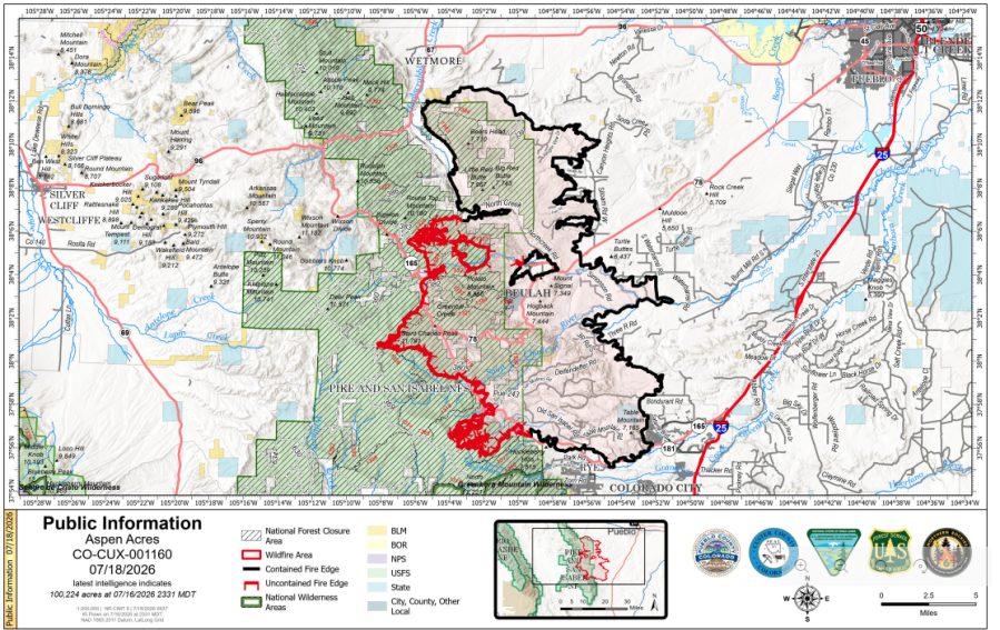
Map of fire
An updated map of the Aspen Acres Fire is shown below. Containment lines are depicted in black.
Evacuations Update
-
An awareness status is in place for Fremont County, encouraging residents to stay informed, monitor official updates, and remain prepared.
-
In Pueblo County, the evacuation status has been lifted for the north and northeastern portions of the Aspen Acres Fire perimeter. Residents south of Highway 96 and north of Highway 78 are allowed to return to their homes. All residents will remain in pre-evacuation status and must be prepared to leave should conditions change. Evacuation status remains on the south side of the fire, with Colorado City remaining in pre-evacuation status.
-
Area C-9B is adjusting back to pre-evacuation status on Saturday at 9 a.m. Wetmore and Greenwood areas remain in pre-evacuation status. The area from Mackenzi Junction Highway 165 south to South Hardscrabble Road opened for residents with Rapid Tag re-entry cards on Friday. Other areas of Custer County affected by the fire remain in pre-evacuation and evacuation status. For Custer County re-entry questions or specific evacuation status, call 719-467-0271.
-
Huerfano County Sheriff’s Office returned all Forest Service land North of CO-69 to the northern-most Huerfano County line to Pre-Evacuation Notice. This includes CR 630 North of CR 630.1 and CR 634 North of 634.2, as well as the entirety of the Greenhorn Wilderness Area. For further information, call 719-738-1044 to reach Huerfano County dispatch.
Evacuation contacts for Aspen Acres Fire
-
Evacuations and pre-evacuations are in place across Custer, Pueblo, Fremont, and Huerfano counties.
-
People are advised to call the Joint Information Center at (719) 583-4640 for information about closures, evacuations, Disaster Assistance Center information, and more for Pueblo and Custer Counties.
-
The Custer County Sheriff’s Office has also opened an information line for community members in Custer County.
-
The information line is open Monday through Friday from 8 a.m. to 6 p.m.
-
The number is (719) 467-0271.
-
If the line is busy, people are asked to leave a message and wait for a call back.
-
-
For Huerfano and Fremont counties, people should visit their county’s social media pages or call (719) 738-1044 for Huerfano County dispatch and (719) 276-7421 for the Fremont County Emergency Operations Center.
Shelter, other information for evacuees
-
Lange Hall
-
3rd St, Westcliffe
-
Small animals accepted
-
-
Pueblo County Recreation Center
-
1650 Cooper Place
-
Small animals accepted
-
-
Pathfinder Park: Livestock and large animals
-
6639 Highway 115, Florence
-
-
Colorado State Fairgrounds: Livestock and large animals
-
1001 Beulah Avenue
-
Enter Gate 7 off of Small Avenue
-
Animal release steps from the Pueblo County Community Animal Response Team
-
Animal releases from the grounds are open from 10 a.m. – 3 p.m.
-
Enter through Gate 7; after that, people will be sent to the paperwork station.
-
People should prepare to provide ownership information for their animals either by providing brand papers, a bill of sale, vet health records, or other related documentation.
-
If those items are unavailable due to the disaster, contact Pueblo County Brand Inspector Zach Kuhn at (719) 225-0137
-
-
-
-
Fire Information Phone Line
-
(719) 697-8353
-
-
Official Fire Information
-
Aspen Acres Fire 2026 Facebook page: Click here
-
-
Joint Information Center
-
The public can call (719) 583-4640
-
-
Colorado Disaster Recovery
-
Click here: Colorado Disaster Recovery
-
-
Colorado 2-1-1
-
Wildfire Resources, or call 211 for fire information or resources. English: 1-844-975-1881 and Spanish: 1-844-975-1882.
-
-
Aspen Acres Fire Disaster Portal
-
Pueblo County access here: Survivor Portal
-
Custer County access here: Survivor Portal
-
-
Crisis Cleanup Hotline
-
Those who need assistance with cleanup can contact the Crisis Cleanup Hotline at (970) 283-7325 to request volunteer help with debris removal, ash cleanup, and other eligible recovery needs.
-
-
Colorado Department of Homeland Security and Emergency Management website
-
Information on the Aspen Acres Fire, with resources available for those impacted by the fire, can be found here: SEOC Update: July 18, 2026
-
Recovery Assistance Center in Pueblo
The following hours and location information are for the Recovery Assistance Center in Pueblo:
-
The DAC is located at Beulah Heights Elementary, 2670 Delphinium St.
-
The Recovery Assistance Center is open from 9 a.m. to 6 p.m. starting Monday, July 20.
Structures lost due to Aspen Acres Fire
The latest updates on structures lost due to the Aspen Acres Fire:
-
According to Pueblo County Sheriff David Lucero, the number of homes and commercial properties destroyed in Pueblo County is 241.
-
Sheriff Lucero said the lost structures include 208 in Beulah, 28 in Rye, two in Colorado City, and three in unincorporated Pueblo County.
-
-
Custer County Sheriff Rich Smith said the total in Custer has climbed to 85.
Road closures due to Aspen Acres Fire
Follow the Colorado Department of Transportation (CDOT) for the latest closures at COtrip.org.
Southern Colorado Wildfire Relief: Where to donate
The United Way of Southern Colorado has organized several ways for the community to donate and help those impacted by the Aspen Acres Fire.
Information on how to donate is below:
-
Visit unitedwaysoco.org/emergencyinfo to donate, view the current list of needed items, and learn more.
-
For monetary donations, 100% of every dollar goes directly to wildfire relief and recovery efforts.
-
-
Drop off much-needed supplies at 1591 Taos Road, Building D, Pueblo, 81006
-
Hours: Monday–Sunday from 7 a.m. to 7 p.m.
-

Copyright 2026 Nexstar Media, Inc. All rights reserved. This material may not be published, broadcast, rewritten, or redistributed.
For the latest news, weather, sports, and streaming video, head to FOX21 News Colorado.
0